Wolds Way, East Yorkshire
- Lee Patrick Wilson
- Nov 23, 2020
- 6 min read

The Wolds Way Public footpath rolls 79 miles over the heartland of rural East Yorkshire from the Humber Gap at the foot of the Humber Bridge and the foreshore of Hessle to Filey Brigg on the North Sea Coast.

Following the high ridge line of white chalk which spans the East Coast of England, best seen at Flamborough yet more iconically known at Flamborough’s southern twin the white cliffs of Dover on the North Sea coast, at both regions the chalk breaks from land to sea, revealing a cross section of white cliffs which rise hundreds of feet from sea level and sink deep into the earths crust some 5000ft below.
The chalk formed from the ghosts of life lived 100 million years earlier at the bottom of the long dried sea bed the legacy of environmental causality as the bones & shells of trillions of life forms that once swam & lived the ocean, fallen somewhere in time, stacked and pressed now give life to this land via stable ground & environment as chalk aquifers which flow deep underground filter & produce clean water essential to today’s life.


The eruption of spring water from these chalk aquifers & glacial melt from the last Ice Age has over millennia sculpted the East Yorkshire landscape through flow & erosion, forging the unique landscape of the Wolds Valleys which themselves rise and fall like an ocean of land, even perhaps mirroring the sea currents from long ago.


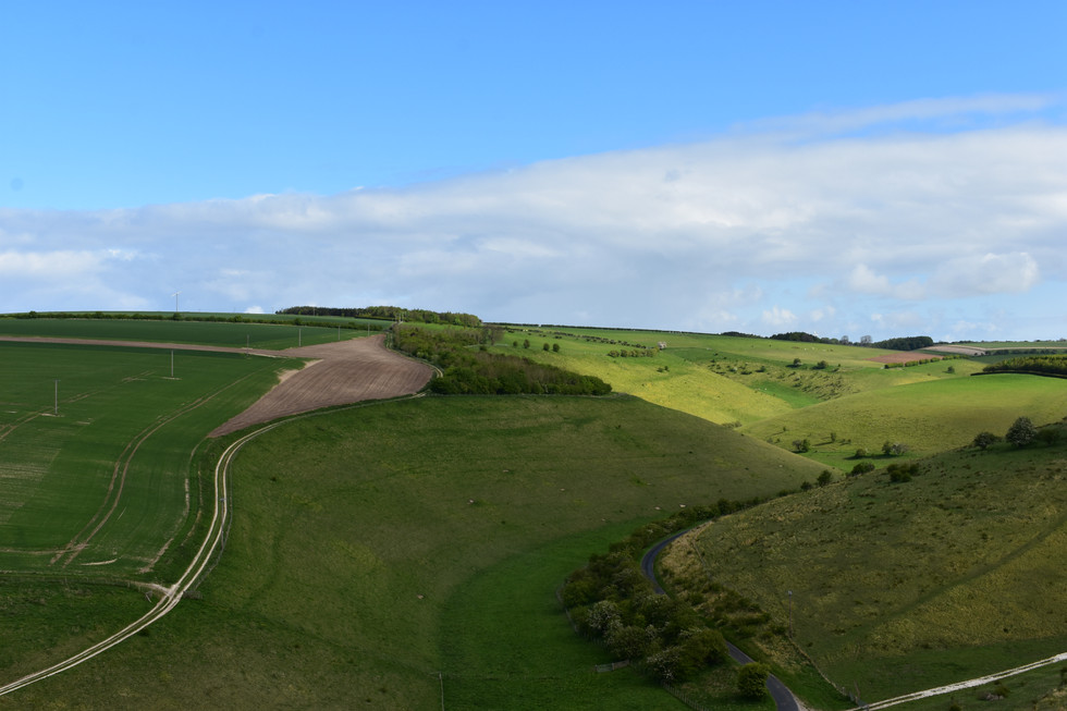


Walking the narrow Public Path which rises high above sea level, the flow and ebb of the chalk spring water & glacial melt can be seen and followed as the land twists and turns, lifts and drops from Valley to Valley. In each Valley the memory of flowing water now visible in landscapes of grass, flowerbed and ploughed earth, emerging from narrow spring heads hidden by rolling country fields, fields of agriculture, tilled and sown for generations in this landscape of Humanity, Prehistory, Geology & water.
The highland of the Yorkshire Wolds rises & divides the otherwise low lying flat region of East Yorkshire into two distinct areas, the far reaching land West and North of the Wolds hills and to the East by comparison the bordered low lying island region of Holderness, which before human engineering and the arrival of Cistercian Monks was a natural landscape of marshland, swamp and fresh water lakes. The chalk here hidden from view lies still, deep below the covering of boulder clay & glacial drift left from the last ice age.
The Holderness region an island within an island bordered to the south by the Humber, East by the North Sea and West by the Yorkshire Wolds can be seen in its entirety from many of the high vantage points along the Wolds way but perhaps nowhere more clearly can this landscape be seen than at the headland of Flamborough which despite not been the official end point of the Wolds Way footpath is the natural geological one.
From the Headland visible on clear days and dark nights from high regions along the cliff tops are the pillars of the Humber bridge, the glow of Hull’s city lights, the cooling towers at Saltend and the lighthouses at Flamborough, Withernsea & Spurn Point.
The low lying fertile River Hull Valley & the Holderness region, this small yet historically influential & unique place I call home, its natural border to Sea, the sweeping Holderness bay against the backdrop of North Sea tides reaches for miles unbroken from Bridlington to Spurn Point, itself reflecting the curved lines of the Wolds and the dynamic nature of this region forged by water.
The view extending out to sea reveals the needs of the society of Modern Man, the industry & people of Britain who above all now hunger for energy, as the landscape and its people spills from land to Sea with engineered silhouettes cast against the rising sun of gigantic metallic human structures of ocean wind farms and north sea platforms which sparkle and shine by nightfall breaking the black expanse of Sea and the night.


To the West of the Wolds far reaching views can been seen which extend from & beyond the Humber following the brown water of the River Ouse to the historic City of York and beyond, the low lying flat lands of the Vale of York, once a glacial lake, the history, wealth and beauty of the region all spread out like a sculpted model the scale diminishing with each mile until imposing cooling towers are tamed by perspective, these fossil fuel burning energy stations which have powered 20th Century Britain can be seen dotted across the land, living relics of human histories industrial past as the emergence & need for sustainability and clean energy in early 21st Century is learned in this place as direly as at any other. As Sea levels rise and flooding exacerbates across this low lying region, year after year causing more extremes of weather. Weather changes caused by human action and the release of energy from the mass of the same prehistoric sea creatures as the chalk is made, the burning and CO2 release causing inadvertent environmental change, environmental causality which this time could spell the end of humanity!
To combat the acceleration of climate change the ensuing cultural shift is seen in action across the vale with the erection of wind turbines generating renewable energy, the tide of change which can be seen extending either side of the Wolds and out across the North Sea. The Vale of York spans far and wide until its own boundary can be seen on a clear day across to the highlands of the Yorkshire dales & Pennines which shield the region from the worst of the West coasts & the Atlantic Ocean’s rain and wind.


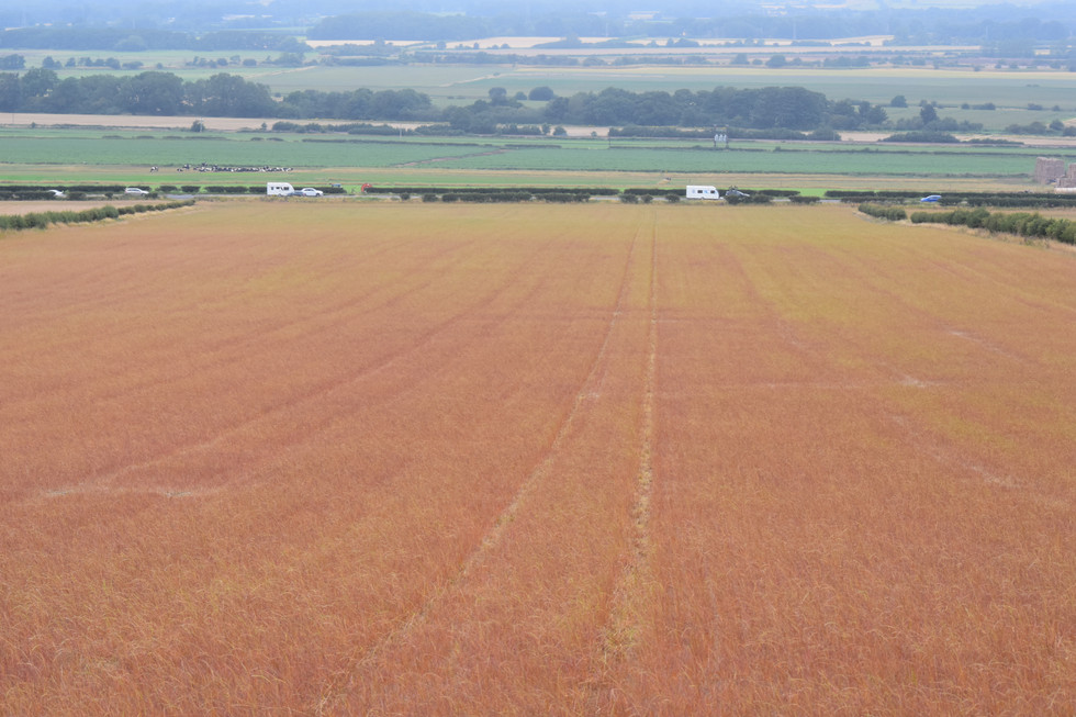
North of the Wolds as the pathway and ridgeline arches East to Sea, the declination of the Wolds is at its steepest, from the high vantage point of the Wolds top running from Winteringham to Staxton, below is revealed the long and narrow Vale of Pickering which extends from the foot of the Wolds West to the Howardian Hills to the incline of the North Yorkshire Moors and the Cleveland Hills which rise from the North side of the Vale forming the visible horizon of the landscape. To the East seaside towns the occasional glimpse of the endless blue sea. The land here once a great glacial lake now resembling a patchwork quilt of Britain, of yellow and golden farmed fields & green forest, the Vale alive with seemingly toy models of human activity, village and church connected by footpaths, train lines and country roads which flow with lines of cars towing caravans filled with people as they make their way to & from holidays and day tripping at sea and coast.


The route of the Wolds Way Public footpath which tells a story in every step, in every mile, the story of this landscape, the story an epic documentary of nature and humanity as the story continues both entwined and connected to one another as hours of walking & exploration are greeted with small rural centers of ancient origin, places of spirit, worship & commemoration, of communities & people from both now and long time passed, market and trade, war and battle, spanning to the earliest human inhabitants of this land, the character of Britain quintessentially human.
The history of this place, the Wolds and East Yorkshire a place of humanity, suited to humanities need for survival allowing us to settle and flourish, a landscape of pleasant climate and accessible land, abundant & gifted with the resource of precious life giving water and due to this wildlife and nature, plants and food ripe in this land, the hard chalk dry and drained a fountain of life, accessible to humanity from the highest peak to the lowest valley, connected by waterways and flood plains once easily travelled with rudimentary timber maritime craft from land to River, to Lake & Sea the landscape over millennia lived and adapted by humanity evolving to the place it is today, shown in the photographs of this land and its people from 2019 to 2020 a snapshot of life as this landscape & humanity continues its dynamic ever changing journey.


Comments